Khao Phra Noe — A hill by a river.

Is that a cool pic or what ?
Khao Phra Noe — A hill by a river.
14 March 2011

location: 
n8.8895 
e98.2949

The map,
showing immediate surrounds.
Our boat, no, the small boat.


Google maps link to my detailed map of the site: http://goo.gl/maps/Lych


View of hilltop
from centre of the river.
This archaeological site is on the mainland, immediately opposite Thung Tuk. It consists of the remains of a small temple atop a small hill. From the hill top one can enjoy an excellent view of the surrounding landscape to the west, and the Takuapa River mouth, which, a thousand years ago, would have been a hive of activity, with ships and commerce from all corners of the world filing the harbour. 

View of Takuapa River mouth from hill top.
whoossh, and away.
This temple was most likely built as a religious ‘good luck’ charm, and as a ‘signpost’. For centuries, ship’s crews arriving and departing for destinations both east and west would be able to look up and know that they were not alone in an often hostile and lonely universe. It also aided in navigation, giving ship’s captains an additional marker to steer by.


The hilltop can be seen from across the bay. Visually, it is backstopped by a higher, darker coloured mountain behind, enhancing its visibility. 
For myself, to reach this spot involved much discussion and planning. Apparently, there is no road route to the hill. With the help of the Fine Arts Dept. book Thung Tuk, I managed to explain to my tuk tuk driver where I wanted to go, who then decided to talk to his tuk tuk mates, and then a number of other locals, in order to put my journey together (this was an official Lost in Translation moment). 


We finally determined that we would travel to a village on a river tributary, and from there take a small boat, approximately 2kms to the hill itself. On the drive to the boat we picked up a man who was the local village headman, a Mr Kamon (as his name transliterated into English), who had been seconded to aid me in my search for the site. As he spoke no English, and my tuk tuik driver knew only basic English, we never really discussed anything of note, however, he got me to the hill top and back.
The hill.
Note the distinctive tree atop.
Easy to spot from the river
So—we reached the village, we embarked (that is to say, myself, the boat driver, and the local village headman), on a small wooden boat (I believe referred to as a ‘long tail’ boat), and travelled approximately two kilometres and 20mins, where upon we reached our landing spot. 


I will say that the view along the river was superb. The water, the green things growing on the side of the river, the blue sky (a somewhat rare near cloudless day). Of course there was the small draw back of the very loud boat motor, which I clocked in the high 80s decibels. The journey out was smooth water, very pleasant, but coming back we experienced some chop.


out landing site.

The landing site was at the end of a narrow canal inland, at a very small beach. We disembarked (not quiet as easy as it sounds). Then the Mr Kamon and myself began walking (our boat driver stayed with his boat) towards the hill. At first we walked over level ground, the hill itself is set back maybe 250m from the shore. Then we reached the hill. 
The climb to the top was not too difficult, but it was tricky, steep in places. Just take it slow and easy, watch out for the spiky plants, and crumbly soil (much of the soil on the western facing side of the hill was crumbly). Let me add though, it was a hike. The day was hot (no cloud), it was humid (the tropics), the air was damp (tropical jungle), and add the previously things listed. It all added up. 

My guide, Mr Kamon,
the village headman.

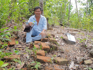
When we reached the top of the hill, ~15 minutes, we saw a central, flat area, with, what looked to me to be, a brick path running northward down the hill. This path was the major and essentially the only man made item on the hill top. There had been a statue of Vishnu present, but it had been removed in 1927 to Bangkok. I surmise that the path was the official or ceremonial route to the top. Most likely, in the old days, the hill top was kept clear of foliage. I am not sure why we did not take this route, but we did not.
Your route to the top. Only 50m high.
We spent over half an hour on the hill. I was snapping pics, wandering around with my gps, and generally recording stuff, while my companion Mr Kamon, took a few pics of me, watched me wander around, and took a swipe at the plants which had overgrown the site. Two or so years ago, when the archaeologists visited, they cleared the site, however, in the intervening time nature had won a lot back. 
The hilltop.
The flat area is where Vishnu once stood.
The brick path is straight ahead,
where Mr Kamon is sitting. 
I estimated the clear area on top to be ~4m on a rough square, there seems to have been a constructed based here, approximately 1/2 metre of the foundation was visible on the western side, upon which the statue of Vishnu would have been placed. The path downwards was on the north-east side of the hill top. The bricks were rather large and well made.
After our time at the top we started back, essentially a repeat of the journey outward. As always, going down is trickier than going up (something I always think of when going up). An hour later we were back at the village. I paid the boat driver the agreed upon figure of 600 baht for his time, ~us$20. Not sure if I was ripped off, but I suspect, if I was, not badly. In comparison, the ferry across to the island of Ko Kho Khao can be booked for 2,000b for one hour! Pang mak as we say in Thailand.
The path downwards.
Closeup of the brick work.
What can I say I learnt from this trip and this site? In a way not a lot, however, seeing an archaeological site gives one a conceptual understanding not easily attained otherwise. Also, it brings home the effort involved in the original construction. We, or at least I, tend to say ‘a small temple’, and these are in truth small, however, think of the effort, time and resources expended in producing these constructs by a low tech culture. The Vishnu statue was fabricated in India, and then shipped 2,000 kilometres eastwards. How difficult would it have been to build this path and platform, and to convey this statue to the top of the hill—a monumental effort indeed. 
I certainly recommend the experience to anyone interested. A day well spent.

Comments

This comment has been removed by the author.
Excellent Sir i think that vishnu statue at Nakhon Si Thammarat Museum. Also they found Tamil Inscription in that place itself which is now at Thalang National Museum at #Phuket (Thailand). Thank You.

Popular posts from this blog

Pattani — the ‘deep’ south of Thailand

First, some advisories: A. ADVISORY: For the last few years and decades there has been an ongoing insurgency in the provinces of Pattani, Yala and Narathiwat (the 'deep south' of Thailand). An average of 600 people have been killed per year between 2004-9. The Australian government strongly urges its citizens not to visit these provinces: "do not travel". Having said this there is no blood on the streets, and life goes on normally for the vast majority of people. In comparison approximately 400 people die every year from traffic accidents in the same region. You have been advised. B. Getting there. There seems to be a scam carried out by the local tour operators to persuade travellers to take mini-buses on journeys between the towns in southern Thailand. These mini-buses cost several times as much as a normal bus. For example, I was quoted 1000 baht (~$35) between Trang and Pattani ~250kms, as compared to 200 baht for a VIP bus. A clear difference. Take the l

The 4,000 Islands of southern Laos - October-November 2019

This cluster of numerous islands is found at the far southern border of Laos in the middle of the Mekong River. Cambo is just a hike away. At this point the Mekong River widens to over a kilometre and reveals many islands (four thousand? I don’t know) above the waterline. In the dry season many of these tiny and low islands are revealed. In the wet season many of these temporary islands disappear under the flooding waters while the main islands suffer from aquatic inundation. So—why go there? In short, relaxation. The 4,000 is the most laid back environment in Southeast Asia. Just what is it? There are two islands that bear the main brunt of tourism. These islands are named Don Det and Don Khon. Each is only a few square kilometres. Most of the land area is given over to rice and agriculture. On Don Det there is a road encircling the island with several roads criss-crossing the island. Next to the jetty is the tourist strip, 100m of small restaura

Robert Heinlein's Starship Troopers—A Critical Critique

The late science fiction author Robert Heinlein was noted for many things, and one of these is controversy. During his life he never shied away from contentious issues, rather he seems to have actively sought them out, both on and off the page. His writing was always provocative, and the most provocative example of this was his 1959 novel "Starship Troopers". The novel was written in a few weeks, prompted by left-wing lobbying for a ban on USA nuclear weapon testing. Heinlein, a strident conservative, vehemently disagreed with this proposal. While the meaning and import of the novel has been debated (it won the 1960 Hugo and is still in print), the story conveys the author's conservative anguish on the perceived flaws of contemporary political and social life. The novel depicts and praises a future government with a sharply limited voting franchise, lauds an authoritarian military, and strongly criticises popular democracy. Essentially, the novel endorses conservative,